
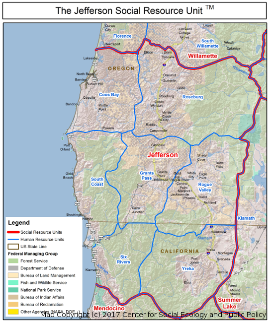
Imagine yourself above the West Coast of the United States looking down on the land that spans the border of Northern California and Southern Oregon. This is where the Siskiyou, Cascade and Klamath mountain ranges converge to create an area of outstanding biological diversity. An amazing variety of plants and animals thrive in the forests, alpine meadows and steep canyons of these mountains.
Fertile valleys are home to buffalo ranches, acres upon acres of fruit and nut orchards as well as miles of rolling vineyards. Towns, large and small are nestled in the foothills. The deep canyons, forests, valleys and watersheds along with the cultural traditions and social structures of the people who live here define the NATURAL BORDERS of this region. In political terms, this is the border between California and Oregon. In HUMAN GEOGRAPHIC terms, it is known as the great State of Jefferson. We did not discover the State of Jefferson. In fact it has a rich history dating back to the 1880s. But we are the first to map the cultural and social boundaries along with the natural geographic attributes of the area.
This alternative mapping system that treats the land and people as one unit is called Human Geographic Mapping.
Why Human Geographic Mapping?
Traditional geopolitical maps create arbitrary lines across the landscape. They do not reflect the natural borders created by the social, cultural, economic and ecological systems (bio-social ecosystems) of a region. Yet for effective policy and project development, the land and the people who live on it must be seen, mapped and understood as one unit. You can read our policy paper on “Climate Change and the Language of Geographic Place” which makes the case that policy development based on human geographic units will make efforts to deal with climate change more effective.
Human Geographic Maps depict specific bio-social ecosystems and portray the attachment people develop to each other and to the land where they live and work. Social, cultural and economic routines along with the geographic features of an area distinguish one population or cultural area from another.
The importance of these maps is to see that people have habitat boundaries that do not correspond to the arbitrary boundaries that govern our formal systems. Policies and projects developed using political maps alone are not sensitive to people’s attachment to the land and result in fragmented governance. Human Geographic Maps depict the people and land as one inseparable unit and are therefore highly enhanced tools for day-to-day management, long-range planning, NEPA (National Environmental Policy Act) documentation and culture-based marketing.
Human Geographic Units
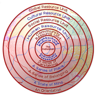
Human Geographic Mapping results in a holistic description of social, cultural and economic trends of a geographical area. This information is organized into 6 scales of human geography from the smallest neighborhood to planet-wide, global systems. These units reflect how residents view their own territory and have proven useful as planning and administrative tools because they match how residents actually relate to their landscapes.
Jump to a scale map and description
Neighborhood Resource Units
An individually possessive perspective characterizes a Neighborhood Resource Unit. The individual identifies with “my house”, “my street”, “my neighbor”, backyards and the local park. There is a high degree of familiarity with one’s Neighborhood Unit and with the people who live there. An individual who is part of this culture may not know the name of every resident of the Unit, but does know generally the types of people who live there and their differences.
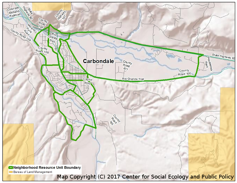
A Neighborhood Resource Unit is quite small. In urbanized areas it usually covers a few city blocks such as the neighborhoods of Salem, Oregon (see map below). Because of its closeness, the individuals’ intensity of perception as to where his neighborhood boundary lies is clearly defined in his mind and strongly held.
In rural areas, small towns or villages may represent a Neighborhood Resource Unit. Outside of these small towns and villages NRU’s may cover even larger geographic areas, encompassing neighboring farms or ranches where most frequent communication and interaction occurs.
Most residents travel outside their Neighborhood Resource Unit to their place of work, to do their shopping, and for most of their other day-to-day activities.
Neighborhood Resource Units physical characteristics include race, income, housing type, age, subdivision development etc., but they are not defined on this basis. Neighborhood Resource Units are defined through a social process on a very personal basis by those living within them.
Neighborhood Resource Units aggregate to form Community Resource Units in the Natural Borders mapping system.
Human resource Units
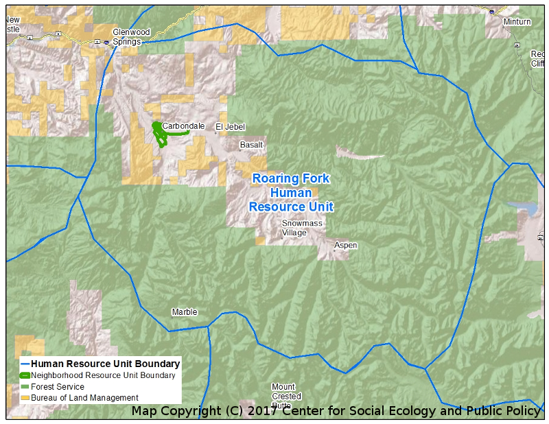
Human Resource Units are larger and encompass a number of Community Resource Units within them. Rather than a perception of personal ownership, as is the case in Neighborhood Units, people at the Human Resource Unit level have more of a perception of ownership as a group, i.e., “our open space.”
A sense of place; a sense of identity with the land and the people; a sense of a common understanding of how the resources of their Unit should be managed; and a common understanding of how things are normally done characterize this territorial level.
Human Resource Units are characterized by frequent and customary interaction. People’s daily activities occur primarily within their HRU including work, school, shopping, social activities and recreation. Health, education, welfare and other public service activities are highly organized at this level with a town or community almost always as its focal point.
The regularity of interaction within an HRU reinforces recognition and identification by the residents of natural and man-made features as “home”. Because of this familiarity, boundaries between Human Resource Units, as with Neighborhood Resource Units and Community Resource Units, are clearly defined in the minds of those living within them.
Human Resource Units aggregate to form Social Resource Units in the Natural Borders mapping system.
Social Resource Units
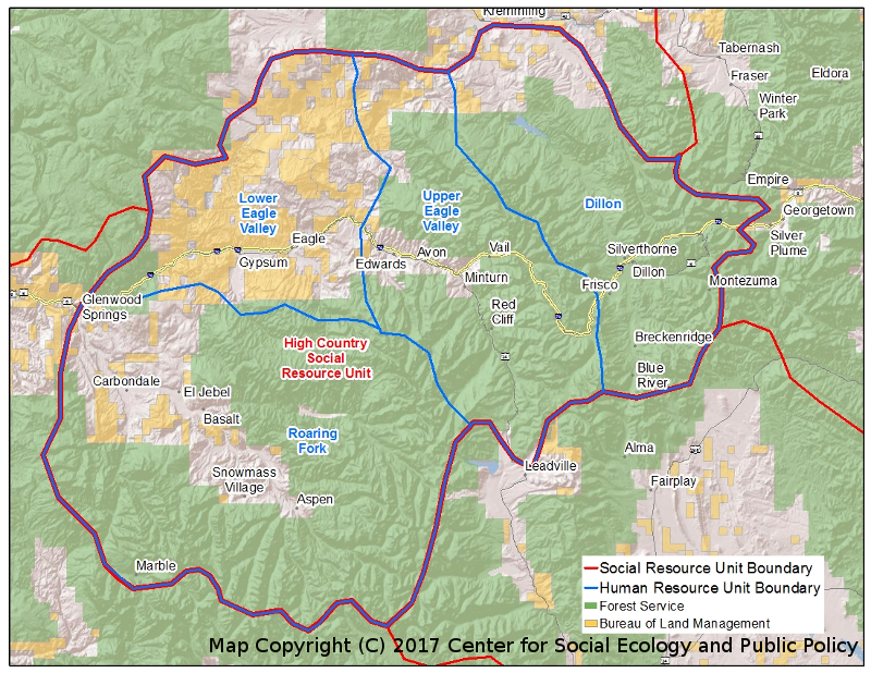
A Social Resource Unit is best characterized by a sense of belonging. These are rather large areas and one’s intensity of perception as to the Unit’s boundary is much more general than at the Human Resource Unit level. A general feeling of “oneness” is held by those who are a part of this regional Unit; and a general understanding and agreement on values and the attributes of being a part of the Unit.
The physical and biological environment has a large role in development of the cultural pattern at this level of the progression because, to a large degree, they determine the kinds of basic industries available for people to develop their culture around, and how the industries function in the most effective manner to preserve and strengthen the cultural pattern of the Unit.
Population density is also a factor that defines and delineates Social Resource Units. Large areas of high population density separate Social Resource Units from surrounding areas of lesser population, but they still reflect in their cultural pattern the broad physical and biological environment within which they occur.
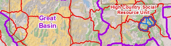
Social Resource Units are usually larger than single cities (the Front Range Corridor SRU, for example, is larger than the metropolitan area of Denver), but are smaller than most states. However, a Social Resource Unit will sometimes include portions of several states, as is the case with the Four-Corners SRU that includes portions of Colorado, New Mexico, Arizona and Utah. The megalopolis of New York City, which includes portions of New Jersey and Massachusetts, is another example of how Social Resource Units are not confined by administrative or legal boundaries. Social Resource Units aggregate to Cultural Resource Units in the Natural Borders mapping system.
Social Resource Units aggregate to form Cultural Resource Units in the Natural Borders mapping system.
Cultural Resource Units
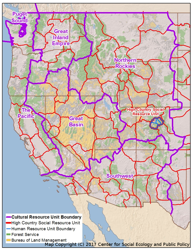
Beyond the Social Resource Unit is the still larger Cultural Resource Unit. This expansive Unit is most accurately described as a “state of mind”. Cultural Resource Units exhibit common cultural patterns of interest, values and lifestyles organized and molded around broad expanses of the physical and biological environment.
Others have also recognized this phenomenon, and different types of “Cultural Units” have been described. Garreau, in his book, “The Nine Nations of North America” defines what he considers a Human Geographic Unit at this higher level of the progression quite well:
“Consider…the way North America really works. It is Nine Nations. Each has its capital and its distinctive web of power and influence. A few are allies, but many are adversaries. Several have readily acknowledged national poets, and many have characteristic dialects and mannerisms. Some are close to being raw frontiers; others have four centuries of history. Each has a peculiar economy; each commands a certain emotional allegiance from its citizens. These nations look different, feel different, and sound different from each other, and few of their boundaries match the political lines drawn on current maps.”
Cultural Resource Units aggregate to form Global Resource Units in the Natural Borders mapping system.
Global Resource Units
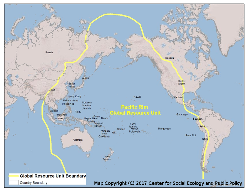
Global Resource Units distinctly separate the globe into functioning value Units based on settlement, history, geography and cultural reference values. An example from Dr. James A. Kent’s article; “The Pacific Rim” illustrates the power of Global Resource Unit recognition:
“We had just finished a five-year process of mapping the Western United States up through the Cultural Resource Unit level. When we looked at our maps, we realized that an almost straight line came south from the Canadian border at about the 100th meridian. It left approximately one-third of North and South Dakota, Nebraska and Kansas on the eastern side of the line. Further analysis of the social, cultural and political realities surrounding this line revealed that people on the eastern side related to Minneapolis-St. Paul, Omaha, Kansas City and Chicago etc., while those on the western side related to the west.”
“The eastern side of the line was settled by wetland farmers who stopped at the “uninhabitable” Great Plains. Settlers crossed the plains to settle the west. Fifty to 75 years later when the major settlement of the Great Plains occurred, it came from the west, not the east. The 100th meridian became the first boundary to distinguish the Pacific Rim world from the Western Alliance world. We had defined our first Global Resource Unit.”
Global Resource Units are key to understanding the world dynamics from a fresh perspective. Natural Borders has identified five preliminary Global Units. The map of the Pacific Rim shows the significance of this Unit. It is clear that the Western United States is participating in an “economic and social” revolution in the Pacific Rim. The Western Alliance policies of “confrontation and containment” based on a Washington-London-Moscow post-World War II strategy does not “work” in the Pacific. Understanding of the reality of the Global Resource Unit allows international policy making, marketing, etc., to be developed within the cultural system of the Unit and reduces the chance of unwittingly dragging alien and destructive concepts from one Unit to the next.
Global Resource Units aggregate to “Spaceship Earth” in the Natural Borders mapping system.